Thursday, April 30, 2015

The hardest part of the training routine

We will be walking through several wine regions in Spain, so we are starting to train our palates to appreciate the regional differences. The map below shows the regions and our approximate route in red. We will skim past Navarra right into Rioja. Later we will be going through Tierra de Leon and then skirt past Bierzo. We will not make it through Ribeiro, but we should be close. 


So far, we have visited the Rioja section in our local wine store. Both wines contained over 95% Tempranillo grapes.


This Aspaldi was our least favorite

But the Finca Nueva got two thumbs up.

Even though we won't be going through Ribeiro, we are being thorough in our research, so we had to try one or two. 

The Ribeiro wines use a grape called "Mencia" that we have not had before. It still seems to have that Spanish taste to it, but in a different way than a Tempranillo.


Today, I'll try to find some Navarra or Leon wines. 

Saturday, April 25, 2015

The Forgotten Catoctin Hike


12 April - Forgot to blog our hike from two weeks ago in the Catoctin Mountains just north of Frederick, Md. This was our second hike with our backpacks and it was 8 miles of rocky and somewhat rugged trail.

After the hike, we went into Frederick to have a drink at Volt restaurant and to walk around the town a bit.

Mike at Chimney Rock


And Sherry is sporting her new hiking shirt. We are starting to hone our equipment for the Camino.


Here is the hike, from the National Park Service web site.


Two More Training Hikes - both on the Cross County Trail


Hike #1 on Sunday the 19th of April is the first of our "Uber" hikes, named for the taxi service that takes us to the starting point. Mike dropped off a car at Oak Mar rec center and rode a bike back home. We then took an Uber to Great Falls to start the hike, and then just hiked to the car. The $20 for an Uber more than makes up for the hour of driving it would take us to stage a car at both the start and end locations.

There is a trail in Fairfax County called the "Cross County Trail" or CCT. It follows the creek beds that run through the county. About 90% of the time you can look left and right and see, off in the distance, the large houses that are typical of this county. However, there is a remarkably woodsy feel to these hikes, as they are along streams and there are lots of trees and greenery all around. You can't beat it for convenience - a nice long flat trail in our own backyard. The trail is sometimes paved, sometimes gravel, sometimes mud and sometimes rocky. Tough for a bike rider, but just fine for walking.

This first hike clocked out at 15.4 miles and we were both pretty beat and a little blistered. We wore our full packs for this one.


Mike among the skunk cabbage. 

Uber Hike #2 on Friday the 24th took us from Lorton, Va right back to our house. The Google Maps said it would be about 15.5 miles, but it actually turned out to be 17.3 miles! Lots of small twists and turns on the trail must have added up. 


Sherry hiking through the wilds of Fairfax County in Wakefield Park. 


Monday, April 13, 2015

What to pack for 6 weeks of walking????


Aah - the joy of trying to decide what to bring and what to leave home when you have to carry every single thing, on your back, for 500 miles. I have it down to about 12 pounds, which includes the backpack itself.  Sherry's load is about 8 pounds because her clothes and shoes are much, much smaller than mine. This will be everything that we have with us for over 6 weeks of travel. There may be some last-minute changes, but the basics are in the photo. Missing items are a simple plastic water bottle that we will probably buy along the way, and my phone which I am using to take the pictures.

We don't have to carry a tent, sleeping pad, cooking gear, or food. We will be buying food at the small towns that we pass through. For lunch and snacks, we'll probably carry a little bit of food for eating during the day, but we won't need much. We are not bringing sleeping bags, because the albergues are generally heated, so we just have a sleeping sheet and some warm clothes.

The Foot Kit: 
Callous scrubber, blister pads, duct tape, white athletic tape, body glide, a small tin of waxy goop, bandaids, toenail clippers, neosporin and fungus cream should keep our feet in working order, Hopefully, some of this will be scrapped along the way as we toughen up.


The Ditty Bag:

Lots of little things in their own little bag:
Safety Pins for hanging laundry, fixing stuff, and for their general utility
String for a clothesline and for tying things to the packs
Sewing kit for tears and missing buttons
Chapstick
A tiny headlamp and extra batteries
Toilet paper
A European-plugged 2-port USB charger and two USB cables
More duct tape
Bandana
A little knife
NSAID for my knees


Nighttime needs:

A hat that pulls down over my eyes
A silk sleeping sack
Eye shades and earplugs
A clean and soft T-Shirt
Wool long underwear


Shower time:

A small plastic bag with soap slices plus other things that you can easily identify yourself.


Rainy Days:

Lightweight umbrella, rain pants, rain jacket


Socks and Underwear:

3 Socks
2 Underwear
1 sleeveless T-Shirt for the hot days
Zipper bag to hold all of my clothes.


Shirts and Jackets:

Short-sleeve cotton shirt
Long-sleeve travel nylon rayon shirt
Wool t-shirt
Puff jacket


Below the belt:

Long pants, and shorts


The backpack and city shoes:


Odds and Ends:

Gaiters, sunglasses, Kindle


On my feet:

My actual walking shoes.


Camino de Santiago in May 2015


We have had a few "training hike" posts, but I don't think that we posted what we are training for. Our next adventure will be hiking the Camino de Santiago, starting in May. It is a 500 mile pilgrimage route in Spain. For us, that's like hiking from DC to Boston (or from DC to NYC and back again). You can go to Netflix and watch the movie "The Way" ( view the trailer here)  to get an idea of what we are about to do, or there are numerous web sites that have information about the Camino.

I am giving an oral presentation to my French class pretty soon, and the slide show that talks about the trip is here at this link. There are a number of trip details in the presentation and some good photos and maps.


The big picture plan for our trip goes like this:

1) Fly into Paris and spend 5 nights there
2) Take the train down to Saint Jean Pied de Port near the border with Spain
3) Walk 500 miles, heading west towards Santiago de Campostella
4) Fly to Madrid and then fly home, 7 weeks after arriving in Paris.

We have made very few reservations so far, because during the hike we will have no reservations. We just show up in the small towns along the way and hope that there will be some beds left in a decent hostel (called Albergues). We have plane tickets into Paris and out of Madrid courtesy of United frequent flier points, we will have an Airbnb apartment reserved in Paris, the train tickets from Paris to the starting point will be reserved, and we have a flight from Santiago de Compostella back to Madrid. Other than that, we are at the whim of the travel gods.

We have been doing a series of training hikes, and have been fiddling with our packing list. We will have to carry everything on our backs during the hike. We will have more posts later, but we felt that the larger plan needed to be stated so that the subsequent posts made sense.


Sunday, April 5, 2015

Training Hikes in Whistler and Our First Hike with Packs


We spent the week in Whistler BC as we do every March- part ski trip, part family reunion. There was shockingly little snow, and no new snow on the way, so we spent more time doing things like hiking and visiting the amazing Scandinave Spa. First, we walked to the Spa and back - probably a 5 mile round trip. The next day, we got more ambitious and mapped out a longer hike up into the hills. It included a stretch of the "Comfortably Numb" mountain bike trail. Here is the route:


We had some stream crossings in the early part of the hike.


These trails are part hiking, part mountain bike. This is a typical construction along the trail that allows the trail to traverse some swampy grounds.


Everything was sooooo green. If there was no moss, it must be the trail. Navigation was a bit sketchy in places as the trails are not marked in any way and they snake through the forest.


Another structure for mountain bikers and hikers.


It is always hard to capture the more extreme variations in terrain using a camera. This photo below shows the mountain bike trail going up and over an incredibly steep and tall section of rock.


The photo below shows the trail going straight down, over a boulder, and then down even more. The wooden slats are so steep that we couldn't walk down them and had to climb down along the side of the ramp. You can see the groove that the bike tires have dug into the boards as they brake on the way down.


A few days later, we hiked just a few miles to "Train Wreck" where seven train cars are sitting in the woods. There was a train wreck in the mid-50's and they just towed the wrecked cars off of the tracks and into the woods. Now, the cars are used for graffiti and as obstacles in a mountain bike course.


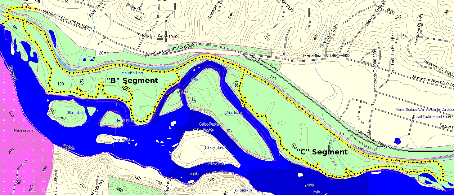
Finally, back home, we hiked 7 miles on April 4th around the Billy Goat trail in Carderock, Md. This was our first hike with our backpacks and we are both a little sore today. Sherry is carrying all of her stuff for a 5-6 week hike. We will be doing laundry.


The B and C sections of the trail, with the C&O Canal connecting them.